Doi Inthanon
Doi Inthanon offers the highest point in Thailand.
If you think it is always hot in Thailand, then you haven't visited Doi Inthanon. Located in the Chiang Mai province, Doi Inthanon is Thailand's highest point, 2,565 meters (8,415 feet) above sea level. Here, bringing outerwear will be a smart move.
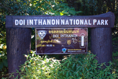
In the photo above from the beginning of November, you can see the temperature was 6 °C (42.8 °F) early in the morning. In the "winter" (December-January), temperatures below the freezing point are not unusual – a far cry from the images of sunny, tropical beaches. However, the temperature rises during the day and usually ends up in two-digit numbers, even in the winter.
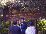
The top of Doi Inthanon is rather boring. There is not much to do here except taking a photo of yourself in front of a couple of signs. Please note, the sign on the first photo is a "fake" sign; you will find the highest point at the sign on the second photo:
If you want more than the photo op for a selfie, you can take a walk on Ang Ka Nature Trail:
However, if you are looking for a view from the highest point in Thailand, you will be disappointed. Fortunately, the trip up to the top is a more exciting. The last hour of the drive to the top of Doi Inthanon offers winding roads and jungle and several waterfalls and viewpoints.
If you buy a trip to Doi Inthanon from a tour desk, you will probably stop at a waterfall or two on the way to the top. The most likely stops are at Wang Khwai Waterfall, Sirithan Waterfall, which you only see at a distance, and Wachirathan Waterfall. If you drive yourself, there are several more waterfalls to choose.
GPS to Wang Khwai Waterfall: 18.501959, 98.666009.
GPS to Sirithan Waterfall: 18.543864, 98.579578.
GPS to Wachirathan Waterfall: 18.541301, 98.599326.
Probably, the tour bus will also make a stop at the two chedis on Doi Inthanon. The two chedis were built to celebrate the 60th birthday of King Bhumibol in 1987 and the 60th birthday of Queen Sirikit in 1992. Unlike at the top of Doi Inthanon, you have a view over the mountains from here. GPS: 18.552738,98.479650.
If the small nature trail at the top of Doi Inthanon left you wanting more, then Kew Mae Pan Nature Trail will satisfy you. You start going through a forest; however, soon you will be walking on mountain trails with a fantastic view. You can get a (slightly foggy) impression of the nature trail in this Youtube video – be sure to watch all of it.
The nature trail is a little less than 3 kilometres (2 miles), and it takes a couple of hours to complete. For safety reasons, access to Kew Mae Pan Nature Trail is only from November 1st to March 31st. GPS: 18.555864, 98.482219.
Getting to the Top
Doi Inthanon is about two hours drive from Chiang Mai. You can buy tours to the top from the tour desks in Chiang Mai, or you can drive yourself.
This article contains prices in Thai baht and in the currency of your choice. The exchange rates are the latest rates from Bank of Thailand ().
The current currency is baht; the exchange rate is 100 baht = 100 baht.
Choose another currency:
We save your choice in a cookie to remember it for other articles.
Doi Inthanon is in a national park, which costs money to visit. If you buy a trip from a tour desk, usually, access to the park is included in the price; be sure to ask them about the fee if you want to compare prices in various tour desks. If you drive yourself, the price is 300 baht (300 baht) for adults and 150 baht (150 baht) for children. A car costs 30 baht (30 baht) while a motorcycle or scooter costs 20 baht (20 baht).
If you want to drive yourself, be aware that the last hour's drive to the top is in a mountainous area with many twists and turns, which can be a challenge if you are not an experienced driver.
On the other hand, if you are an experienced driver and you think driving with a lot of twists and turns is fun, you may want to do the Mae Hong Son Loop route from Chiang Mai to Mae Hong Son and back to Chiang Mai. You can visit Doi Inthanon as a detour on the loop.
At this Google Map, you can see the Mae Hong Song Loop with landmarks and viewpoints; the map also includes the trip to Doi Inthanon and a loop from Chiang Mai to Chiang Rai and back to Chiang Mai.


